Why is Shetland sinking faster than Fort William?
Understanding sea level rise in Scotland means looking beyond global averages to the local forces still shaping our shores today. Scotland’s coastline is changing – but not in the same way or at the same pace everywhere.
By Alastair Dawson
The coastline of Scotland is characterized by a variety of raised beaches of different ages and origins. Yet in some areas, for example, the Outer Hebrides, Orkney and Shetland, there are no raised beaches in the coastal landscape. The reason for this contrast arises from the response of Scotland’s crust to the initial loading by an ice sheet that reached its maximum extent ~22,000 years ago and its eventual melting ~10,000 years ago. The ice sheet was more than 1 km thick at its centre in the western highlands and it depressed the Earth’s crust beneath its weight. Closer to the margins of this former ice sheet, sub-crustal material was forced upwards across a forebulge zone that acted to compensate for glacio-isostatic depression underneath the central part of the ice sheet. Since deglaciation, glacio-isostatic rebound has taken place differentially with rises in areas where the ice was formerly thickest, whereas closer to the margins of the former ice sheet crustal depression caused by the collapse of forebulge areas continues to take place. At present, the maximum rate of vertical crustal rebound is in the order of between 1-2 mm per year across the Fort William -Rannoch Moor area where the ice was formerly thickest. By contrast, in peripheral areas, such as Shetland, Orkney and the Outer Hebrides, crustal depression caused by forebulge collapse may be continuing.
The impact of climate change on Scotland’s coastal areas
For Scotland, the practical implication of accelerated melting of the Greenland ice sheet caused by recent climate change is to induce a lowering of the regional sea surface across the northern North Atlantic as a result of gravitational relaxation of the ocean surface. Yet this trend of sea-surface lowering is counterbalanced by a glacio-eustatic increase in global ocean mass resulting from the melting of glaciers and ice sheets worldwide, particularly the West Antarctic Ice Sheet and the Greenland Ice Sheet as Sugden describes in his paper. The nature of sea level change around Scotland’s coastline is further complicated by a raising of the sea surface caused by long-term thermal expansion of ocean water due to the uptake of heat from the atmosphere. This increase in sea level is distinctive since it is characterized by an increase in global ocean volume, but no change in its mass.
Regional difference in sea level rise
The predictions of sea level rise into the future by the Intergovernmental Panel on Climate Change (IPCC) are profoundly influenced by the rate of oceanic thermal expansion that will always increase as long as the concentrations of CO2 in the atmosphere continues to rise. The combination of ongoing differential crustal rebound of the majority of Scotland’s landmass coupled with the collapse of forebulge areas as well as gravitational disturbance of the North Atlantic Ocean due to Greenland ice sheet melting, means that Scotland’s coastline is experiencing different rates of relative sea level rise and will continue to do so in the future. It is therefore not surprising that the current rate of relative sea level rise in the Fort William area, where crustal rebound is greatest, is no more than 1 mm per year while in the Shetland Isles, in an area of forebulge collapse, the rate of relative sea level rise is closer to 4 mm per year.
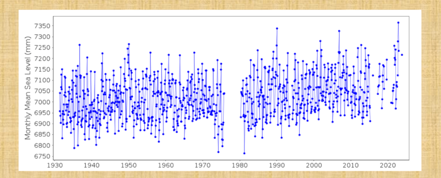
For Scotland, these competing oceanographic and crustal deformation processes are presently resulting in a rise in regional sea level that is less than that described in the IPCC reports. This is evident in the patterns of relative sea level change recorded by tide gauges. There are relatively few tide gauges in Scotland, for example across the whole of eastern Scotland there are only two – Aberdeen and Leith. The Aberdeen tide gauge record, maintained under the auspices of the International Oceanographic Commission and the Permanent Service for Mean Sea Level, provides a local chronology of relative sea level change for nearly a century (Figure 1). The graph of change for Aberdeen not only highlights the ‘noise’ of short-and medium-term tidal cycles, but it also shows a gradual rise in relative sea level over that last ~90 years. The Aberdeen tide gauge record is thus of considerable significance since it demonstrates that the rate of regional relative sea level rise that is indicated for recent decades is much lower than the estimated global average. Planners and policymakers take note!
- This article is part of a series from the RSE’s Environment Community of Interest. The aim is to stimulate informed public debate on the many aspects and elements of this complex and vexed subject. We’d love to hear your thoughts about this piece, email us on publicpolicy@theRSE.org.uk.
- To be notified when the next article in this series is live, sign up to the RSE’s monthly policy advice newsletter.
- The RSE’s blog series offers personal views on a variety of issues. These views are not those of the RSE and are intended to offer different perspectives on a range of current issues.
Resource Type
BlogPublication Date
01/05/2025You might also like
-
Resources

How can we navigate a world where truth is increasingly contested?
-
Resources
Scotland’s housing system faces a deepening polycrisis, driven by rising costs, weak income growth, and fragmented policy. Despite political recognition of the emergency, current responses remain limited.
-
Resources
From Skye to the Highlands, rural Scotland is caught between tourism growth and community wellbeing. Professor Sandro Carnicelli explores why a new approach is needed.


